Navigation
HYPE Documentation
Quick links to often-used pages:
HYPE links
HYPE OSC (model code)
HYPE Open data access
SMHI Hydrology Research Dep., main developer and maintainer of the HYPE model
Quick links to often-used pages:
HYPE OSC (model code)
HYPE Open data access
SMHI Hydrology Research Dep., main developer and maintainer of the HYPE model
A river or lake that flood over its borders and cause a large area of standing water may be simulated with the HYPE floodplain functionality. Read more about how the floodplains work in the model description section Floodplains.
A HYPE floodplain can only be formed from water that flows from a main river or an outlet lake; local streams and internal lakes cannot have an associated floodplain area. The floodplain and its water body are considered as one unique slc-class, and this class' area is the maximum extent of the floodplain. This means that floodplains do not constitute a new slc class and therefore the (previous) class area, that is the water body area (of main river or outlet lake), becomes larger to include the possibility to be flooded.
The modelled floodplains are described mainly by information given in the FloodData.txt file and by some parameters in the par.txt file. To use the floodplain model its model option is set in info.txt. The information in FloodData.txt can be grouped in three categories:
fpfol, fpfmr)floll, flolp, flmmr, flmrp, fymol, fymmr)rclfp, rcfpl, rcrfp, rcfpr).These input data can be estimated in different ways. The suggestion here is to define those that can be observed/derived relatively easy from data (area and elevation threshold) and manually calibrate the others (recession coefficients). A method to do that is described below:
Area related data
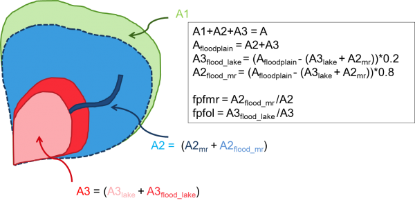
fpfmr and fpfol are defined this way.  |
Figure 1: Example of determining fraction of floodplain area (fpfmr and fpfol). A represents the whole subbasin area, the subscripts lake and mr, outlet lake and main river, respectively. |
Elevation thresholds
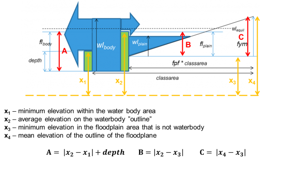
flmrr and floll), B (flmrp and flolp) and C (fymol and fymmr). A is the threshold for flow from water body to floodplain. B is the threshold for flow from floodplain to water body. C is the highest elevation of the floodplain, i.e. the water level when the flood reaches its maximum areal extent.  |
| Figure 2: Illustration and definition of elevation (xi) and floodplain input (A,B,C) variables. Suggestion for determination method of elevation variables. |
deadm is a general parameter (par.txt). This parameter needs to be larger than 0, when floodplains are simulated. We took it from E-HYPE and it has a value of 0.005 m2 km-2flmrr and floll) and the threshold for flow from floodplain to water body (flmrp and flolp) can be set to zero as a starting value. modeloption floodmodel 3, two extra input data are needed (hrefr and hrefl). These are the floodplain threshold in an absolute reference system. For these the value x2 can be used.Recession coefficients
rcrfp, rcfpr, rclfp, rcfpl). The recession coefficients must be between zero and one. A recession coefficient of one gives a fast response. These coefficients usually need to be calibrated.Model parameters
A few parameters from par.txt need to be mentioned in relation to floodplains.
deadm, should not be changed after/if it has been used to determine the thresholds. The parameter, if larger than zero, lets the river hold a water volume after the flow from the river has stopped. This can be important if you simulate substances. It can also delay the start of flow after a dry (zero-flow) period by being filled up with inflowing water replacing evaporated water during the dry period.cevp, ttmp, both land use dependent) for the land use defined for these classes.srrcs, land use dependent) should be set to 1 for lake and river classes with floodplains. Then no water will be left standing on the dry part of the floodplain, but will be added to the flooded water.optonoff, and the parameters are called opt1, .., opt8. Different values for optonoff will replace different sets of floodplain data. You can replace none (optonoff=0) or all of them (optonoff=1), but alternatively replace only thresholds (optonoff=2), only recessioncoefficients (optonoff=3) or only maximum extent of floodplain (optonoff=4). opt1 | replacing floll |
opt2 | replacing flolp |
opt3 | replacing flmrr |
opt4 | replacing flmrp |
opt5 | replacing rclfp and rcrfp |
opt6 | replacing fymol |
opt7 | replacing fymmr |
opt8 | replacing rcfpl and rcfpr |
The parameters are described in par.txt.