User Tools

Site Tools


start:hype_tutorials:floodplain_tutorial

This is an old revision of the document!


Lake and river floodplain tutorial

A river or lake that flood over its borders and cause a large area of standing water may be simulated with the HYPE floodplain functionality. Read more about how the floodplains work in the model description section Floodplains.

A HYPE floodplain can only be formed from water that flows from a main river or an outlet lake; local streams and internal lakes cannot have an associated floodplain area. The floodplain and its water body are considered as one unique slc-class, and this class' area is the maximum extent of the floodplain. This means that floodplains do not constitute a new slc class and therefore the (previous) class area, that is the water body area (of main river or outlet lake), becomes larger to include the possibility to be flooded.

The modelled floodplains are described mainly by information given in the FloodData.txt file and by some parameters in the par.txt file. The information in FloodData.txt can be grouped in three categories:

  1. area related data; area fractions between floodplain, water bodies and subbasins (including fpfol, fpfmr)
  2. elevation thresholds; thresholds between water body and flood plain and between water body and downstream lake/river (floll, flolp, flmmr, flmrp, fymol, fymmr)
  3. recession coefficients; coefficients to regulate the flow between water body and floodplain (rclfp, rclpl, rclfp, rclpr).

These input data can be estimated in different ways. The suggestion here is to define those that can be observed/derived relatively easy from data (area and elevation threshold) and manually calibrate the others (recession coefficients). A method to do that is described below:

Area related data

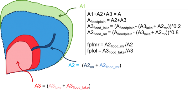
  • Determine how large area of the subbasin that can be flooded (e.g. from floodplain delineation databases, literature, etc.). Then specify how much of the floodplain area is flooded by water coming from the outlet lake (olake) and/or main river (e.g. 20% from olake and 80% from river). See example in Figure 1 where the values fpfmr and fpfol are defined this way.
Figure 1: Example of determining fraction of floodplain area (fpfmr and fpfol). A represents the whole subbasin area, the subscripts lake and mr, outlet lake and main river, respectively.
  • Introduce the area changes in GeoData.txt. A new distribution of the SLC classes' area fractions is needed, reducing the non-water classes area in favor of the water areas. Remember that the new olake area (A3 in the example in Fig 1) is composed of the original outlet lake area (A3lake) plus the area flooded by the olake (A3flood_lake); same for the new main river area. The area of the subbasin that is not flooded can be distributed between the non-water classes present in the subbasin before the changes using the same distribution as before or it can be distributed among a subset of these classes. Remember that the sum of all classes' area fractions in a subbasin needs to be one.

The input data values needed can be estimated in different ways and also be calibrated in HYPE. Here we describe one method to determine input data. For each subbasin that have a floodplain repeat these steps:

  1. Determine how much of the floodplain area in the subbasin that shall belong to the main river and to the outlet lake (if any). Calculate the slc-fractions for main river and olake classes accordingly (e.g. floodplain area of the river + river area together make up the area of the main river class). You may have to reduce the other classes’ slc-fractions so that the sum over the subbasin is still 1. Put the new slc-fractions in GeoData.txt.
  2. Calculate the fraction of the main river and olake classes area that is floodplain. These fractions are entered into FloodData.txt variables fpfmr and fpfol. The rest of the classes' area is river or lake surface area.
  3. The slope of the floodplain areas is determined from elevation data. The floodplain is approximated with a linear relation to area (see Figure 8 in model description). The difference between the lowest elevation and the highest elevation of the floodplain (approximated as linear) are set as water level at maximum areal extent. These are entered into FloodData.txt variables fymmr and fymol.
  4. The threshold for flow from water body to the floodplain is given a value. For an outlet lake this should be normally larger than the lake depth (if outflow occurs before the lake floods over to the floodplain). For a river the threshold can start with a value of zero if nothing better is known. These values are set to the FloodData.txt variables flmrr and floll.
  5. The threshold for flow from floodplain to water body is given a value. If nothing better is known start with zero. This is set to the FloodData.txt variables flmrp and flolp.
  6. The water levels of the river/lake and floodplain will try to reach equilibrium. The speed of equalization is determined by recession coefficients that say how far to equilibrium the water level will reach on one time step. There are separate recession coefficients for flow to and from the floodplain and for main river and outlet lake, in total 4 possible parameters (rcrfp, rcfpr, rclfp, rcfpl). The recession coefficients must be between zero and one. A recession coefficient of one gives a fast response.
start/hype_tutorials/floodplain_tutorial.1528465641.txt.gz · Last modified: 2023/11/16 14:28 (external edit)